The National Park Kornati
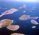
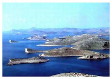
In the central part of the Croatian Adriatic, on the meeting point of Šibenik and Zadar islands, a separate and by many a specific group of islands, called Kornati, is situated.
Because of its exceptional landscape beauty, interesting geomorphology, diversity of the coastline and especially because of the rich biocoenoses of the marine ecosystem, greater part of the Kornati maritime zone has been declared a national park in 1980.
Today NP “Kornati” occupies an area of about 220 km2 and it includes 89 islands, islets and cliffs, alltogether with a coastline about 238 km long. Despite this relatively large number of islands the continental part of the park forms only 1 of the total area, while everything else belongs to the marine ecosystem.
Cultural heritage
The incredible combination of nature and man, who lives in Kornati for several thousands of years (as it has already been proven), which among other things reflects in always modest, but impressive buildings (port, flats, dry stone walls, olive groves, piers, forts, castles, churches, salt pans, ruins, etc.), which are additional and worthy decoration of the Kornati National Park area.
Relatively large distance from the coast, biological richness of the marine area, pirate holdups, good pastures, barren karst soil, good shelter for an ugly time at sea, ... – these are all reasons for which Kornati have been both hospitable and inhospitable area throughout the human history. Constantly on the border of being populated or being unsettled, peace and turmoil, wealth and poverty, Kornati have always been a challenge for different cultures and different interests in this region.
The first traces of man's presence in the area of the Kornati islands date back to the Neolithic. This assumption is supported by the discovery of stone axe found in the field Zejkovci, at the foot of the hill Pedinka on the island of Kornat.
The first confirmed colonization of the Kornati islands dates back to the time of the Illyrians. Small square dwellings, individually or in groups (such as below Pedinka above Zeljkovci, Podselo by Trtusa, and Grba on Zut), ruins (Scikat, Strazisce, Tureta, Grba) and tumuli (almost on every the hill on the islands of Kornat and Zut), testify about the significant population of the islands during the prehistorc times. Livestock was the main economic activity, but fishing also played an important role in the economy for the inhabitants.
Even to the Romans this area seemed interesting and attractive for housing and economic exploitation. The Roman building of Villa rustica in Proversa and fish pool on Svrsata cut (as believed) the unique living space of the Illyrians in Kornati and Dugi Otok, which was, by some authors, probably the critical event for the continuity and intensity of the Illyrian settlements in this region. Other traces of antique buildings that testify about the Roman colonization of the Kornati are now mostly under the sea: the berth in Piskera and Sipnata, harbor in Vela Proversa, salt pans in Sipnata.
Byzantine period left according to numerous experts the most imposing building, which can be found today in the Kornati: Tureta fort on the island of Kornat (Architecture of Late Antiquity and Early Middle Ages - probably from the 6th century). It is supposed that the fort had a military purpose of securing and controling navigation through the Adriatic Sea, which was quite uncertain at the time.
A very interesting building from the Byzantine era is also the early three-apse Christian basilica, which is located at the foot of the fort Tureta, and whose greater part of the apse and a part of the former foundations are still visible. Given the size of the church (30 x 13 m), it is assumed that there was a considerable number of inhabitants on the Kornati islands at the time. In the immediate vicinity of the church (in today's sheep fold), there are traces of foundations of a former building for which there is a doubt whether it was a monastery of the Templars or a Benedictine monastery. It is interesting that the island of Kornat was called names like Insulae Sanctae Mariae, Stomorin island, etc. throughout the Middle Ages according to exactly this church (St. Mary's church).
The arrival of the Croats to the Adriatic Sea caused larger demographic changes on all islands, therefore on Kornati, too. The Roman population, due to the invasion of Croats was forced to flee from the land and seek refuge on the islands. Considering the fact that the sea represented an obstacle for Croats for only a short period of time conflicts with Venice soon came to expression, because Venice wanted to dominate Dalmatia. That time – the time of weakening of the Byzantine, Venice was growing stronger and arrival of Croats to the Adriatic Sea – was a very critical time for the population of the Kornati. Back then the Kornati were a very insecure life space, so that it is assumed there was no constant inhabitants on Kornati up to the 13th century.
In the 13th century Kornati started resuscitate. Some very interesting cultural buildings in the national park area date from the Middle Ages. The most impressive is certainly the church of Our Lady of Tarac, a modest one-apse building (type of rural late Romanesque church), built on the site of an early Christian basilica and most likely from the remains of the old church. Time of the construction of Our Lady of Tarac is not entirely clear, so there are assumptions that it was built in the 12th/13th century, 14th or 15th/16th century. Today masses are held in this chirch (every first Sunday in July), whose meaning has outgrown the exclusively religious boundaries and become a part of the tourist attractions of the area. The remains of warehouses for salt and remains of salt pans in the bay Lavsa date back to medieval ages (probably the second half of the 14th century).
Medieval written traces indicate the presence of cattle breeders and farmers in the Kornati islands. The value of the islands grew with the upsurge of Turkish threats on the coast, but also because of the fishery that was becoming more and more significant for the economy in the region. The interest in Kornati has particulary increased after the new way of fishing sardines was introduced in 1524 (the use of light). A place called Sali on Dugi Otok has already been an important fishery centre since the early Middle Ages, but from the beginning of the 16th century it becomes the most important fishery centre in the Adriatic next to Vis and Hvar, especially due to the Kornati. Namely, the fishermen from Sali had the exclusive right to fish in the area of Kornati at the time. On an islet called Vela Panitula a Venetian castle was built at the beginning of the 16th century whose purpose was to collect fishing tax from the Kornati fishermen. Namely, the Venetian authorities ordered the Kornati fishermen in 1532 to bring their catch to the islet of Vela Panitula for tax collection. Nearby the Venetian castle, on the island of Piskera (Jadra) the fishermen built a settlement with 36 small houses and warehouses, eight piers and a drawbridge between Vela Panitula and Piskera, which was rather big, considering the time and space. A one-apse church was also built within the settlement, with gothic construction elements, and it was consecrated in 1560. The fishermen were only staying in the settlement during the summer “darkness” (the best time to catch oily fish - when there is no moon in the sky). Taking all facts into consideration one can conclude that the castle and the whole settlement of Piskera vanished with the fall of the Venetian Republic by the end of the 18th century. It is interesting that one can hardly see the traces of the settlement today, while the castle has turned into “remains of the remains” - reliquiae reliquiarum. The church has been, on the other hand, restored, and is still in function.
Because of increasing insecurity in Kornati during the 17th century on one hand (frequent pirate livestock stealings, executing of the shepherds on the galleys, etc.), and more developed and lucrative fishing on the other hand, Kornati were practically left without people. Serfs who had previously worked for the owners of the Kornati islands (noblemen from Zadar) have turned to new sectors and new regions. Local residents of Murter, Betina and Zaglava took this gap as an advantage.As new colony residents of noblemen from Zadar, they were seeking for additional life space (in Murter Kornati were mentioned for the first time in 1627 year).The island of Murter in fact became overcrowded due to the invasion of the refugees who fled from the Turks from the mainland and it was not able to feed so many people. Economically speaking, there were two kinds of people at the time in the Kornati archipelago: 1) Farmers and shepherds from Murter and 2) the fishermen from Sali.
Since the arrival of the new colony administrators until the end of the 19th century, conditions in the Kornati islands have not changed at all. Documents about life on Kornati are very scarce. At that time, the first field and pastoral dwellings (apartments) were built - small rural properties were situated along the edges of the fields in Kornati. The cadastral maps from 1824 to 30 enrolled 187 colonies with Murter as their domicile settlement. These posts are related mainly to the interior of islands (they are not on the seaside). However, it is important to emphasize that already in 1682 the documents mention that the residents of islands of Murter and Pasman and the neighboring mainland were becoming real "interference" for the Sali fishermen. Since then, conflicts over fishing rights in the Kornati have been constantly increasing.
During the late 19th century, the Zadar nobility as the former owners of the Kornati land was no longer able to pay taxes and levies – due to the new agrarian policy in Dalmatia-, so they all sold the Kornati islands. In 1885 residents of Murter island bought the island of Zut, and in 1896 they bought, together with residents of Betina and Zaglav, the island of Kornat with all pertaining islands. Residents of the island of Murter have in this way become owners of over 90% of the Kornati land. The peasants were still taking care of the sea considering the traditional and written right to fish they have had during the whole history of the islands.
At the end of the 19th anf the beginning of the 20th century the economy and life on Kornati islands have gained a completely different meaning. That was the time of the strongest agrarian activities. Purely pasture areas experienced the biggest transformation when speaking about the increase of the cultivated surfaces (the area of clear land became ten times larger). At the same time a complex mosaic made out of drystone wall fences sprang, and today we consider it to be one of the most interesting cultural attractions in the park area. Life was slowly relocating from the interior of the islands to the seaside. The ports, settlements in marine suitable bays, gained their full importance in the 20th century.
During the 1920’s clearings of the land (expansion of the agrarian surfaces) were recorded. From that time on the traditional economy has begun to stagnate, and during the last few decades tourism, as a new economy branch, has taken a dominating position. Unfortunately, a direct consequence of tourism development is that the same number of houses has been built in Kornati in the last 50 years as it was during the whole history of this area up to that moment.
3/27/2010
9/09/2007
Most beautiful sea on the Earth
Something about Adriatic Sea
The Adriatic Sea is a body of water separating the Italian Peninsula from the Balkan peninsula, and the system of the Apennine Mountains from that of the Dinaric Alps and adjacent ranges. The Adriatic Sea is a part of the Mediterranean Sea.
The western coast is Italian, while the eastern coast runs mostly along Croatia, Montenegro, Albania, Slovenia and Bosnia and Herzegovina (26 km). Major rivers joining the Adriatic are the Reno, Po, Adige/Etsch, Brenta, Piave, Soča/Isonzo, Zrmanja, Krka, Cetina, Neretva, Drin (Drini).
Name and etymology
The name has existed since antiquity; in the Latin of the Romans (Ancient Latin) it was Mare Superum; in medieval Latin it was Mare Hadriaticum or Mare Adriaticum. The name, derived from the Etruscan colony of Adria (or Hadria), originally designated only the upper portion of the sea (Herodotus vi. 127, vii. 20, ix. 92; Euripides, Hippolytus, 736), but was gradually extended as the Syracusan colonies gained in importance. The word Adria probably derives from the Illyrian word adur meaning "water" or "sea".
But even then the Adriatic in the narrower sense only extended as far as the Monte Gargano, the outer portion being called the Ionian Sea: the name was sometimes, however, inaccurately used to include the Gulf of Tarentum (the modern-day Gulf of Taranto), the Sea of Sicily, the Gulf of Corinth and even the sea between Crete and Malta (Acts xxvii. 27).
The Adriatic Sea is situated largely between the eastern coast of Italy and Croatia, which are both major tourist attractions. It was used by the ancient Romans to transport goods (including animals and slaves) to Ostia (the Roman port).
Extent and bathymetry
The Adriatic extends northwest from 40° to 45° 45' N., with an extreme length of about 770 km (415 nm, 480 mi). It has a mean breadth of about 160 km (85 nm, 100 mi), although the Strait of Otranto, through which it connects at the south with the Ionian Sea, is only 45-55 nautical miles wide (85-100 km).[3]
Moreover, the chain of islands which fringes the northern part of the eastern shore reduces the extreme breadth of open sea in this part to 145 km (78 nm, 90 mi). Its total surface area is about 60,000 square miles (160,000 km²).
The depths of the Adriatic near its shores share a close relationship to the physiography of the nearby coastlines. Wherever the coasts are high and mountainous, the nearby sea depths are considerable. For instance, in the case of the Istrian and Dalmatian areas of Slovenia and Croatia., the shores are low and sandy, and the nearby sea is shallow, as in the vicinity of Venice or, farther south, near the delta of the Italian Po River. Generally speaking, the waters are shallow all along the Italian coast. The site of maximum depth of the Adriatic Sea is situated south of the central area, and the average depth is 1,457 feet (0.444 km) and maximum depth is 3,300 feet (1.0 km).
Coasts and islands
The west shore is generally low, merging, in the northwest, into the marshes and lagoons on either hand of the protruding delta of the river Po, the sediment of which has pushed forward the coastline for several miles within historic times—Adria is now some distance from the shore.
On islands within one of the lagoons opening from the Gulf of Venice, Venice has its unique situation. Other notable cities on the Italian coast are Trieste, Ravenna, Rimini, Ancona, Pescara, Bari, and Brindisi.
The east coast is generally bold and rocky, with many islands. South of the Istrian Peninsula, which separates the Gulfs of Venice and Trieste from the Bay of Kvarner, the island-fringe of the east coast extends as far south as Dubrovnik. The island of Cres is the largest island in the sea, slightly larger than nearby Krk.
The islands, which are long and narrow (the long axis lying parallel with the coast of the mainland), rise rather abruptly to elevations of a few hundred feet, with the exception of a few larger islands like Brač (Vidova gora, 778 m) or the peninsula Pelješac (St. Ilija, 961 m). There are over a thousand islands in the Adriatic, 66 of which are inhabited.
On the mainland, notably in the Gulf of Kotor (Boka Kotorska; named after the town of Kotor), lofty mountains often fall directly to the sea.
The prevalent colour of the rocks is a light, dead grey, contrasting harshly with the dark vegetation, which on some of the islands is luxuriant. In fact, Montenegro (Black Mountain) was named after the black pines that cover the coast there, and similarly the Greek name for the island of Korčula is Korkyra Melaina meaning "Black Corfu".
It is interesting to note the vast difference between the Italian and Croatian coasts on the Adriatic. Although only a small distance from each other, the Croatian Coast and beaches are generally many times clearer, cleaner and bluer than Italy's. Croatia is known for its Crystal clear water.
Major cities on the eastern coast include Trieste in Italy; Koper, Izola and Piran in Slovenia; Umag, Poreč, Rovinj, Pula, Opatija, Rijeka, Senj, Zadar, Biograd, Šibenik, Trogir, Split, Makarska, Ploče and Dubrovnik in Croatia; Neum in Bosnia and Herzegovina; Herceg Novi, Kotor, Tivat, Bar, Budva and Ulcinj in Montenegro; Shkodër, Lezhë, Durrës, Fier and Vlorë in Albania.
Weather patterns
The bora (northeast wind), and the prevalence of sudden squalls from this quarter or the southeast, are dangers to navigation in winter. Also notable are sirocco (southern wind) which brings rain in the winter and maestral (western wind) which brings serene weather in the summer. The area is known for occasional waterspouts similar to those found in the Florida Keys.
Tidal movement is slight. The amphidromic point is just off the northwestern shore, near Ancona.
Subscribe to:
Comments (Atom)
map of adriatic sea

Adriatic sea





.jpg)